
i-quadrat
Optimization of intra-communal information flows – practical working aids using the example of adaptation to heavy rain events
(Municipal lighthouse project for adaptation to climate change, grant number 03DAS106 of the Federal Ministry for the Environment, Nature Conservation and Nuclear Safety)
funded by:
Heavy rain is one of the consequences of climate change. In order to be able to take precautionary measures and be able to plan in a focused manner, existing knowledge must be collected and exchanged. That is why a municipality needs
a) Information on the current situation and possible future scenarios
b) an infrastructure for storing and linking the information
c) permission to use and distribute data and information.
Building on the previous project RainAhead (03DAS014) and in cooperation with the cities of Fehmarn and Hameln scientific principles, spatially accurate information and practical experience were communicated to the general public and further expanded through knowledge from the population and stakeholder groups. Another goal was to anchor the topic in the administration of the municipality of Lübeck.
Project partners were the Technical University of Lübeck and the Hanseatic City of Lübeck, as well as the lawyer partnership Donoth Fuhrmann Tüxen and the surveying office Holst und Helten as other associated project partners.
The main success points of the project are the improvement of the following information flows:
Within the municipality
- Raising awareness and knowledge transfer through workshops within the municipal administration
- Definition of a data model harmonizing with the EU INSPIRE directive
- Network analysis of the responsibilities of all actors
Citizens >> municipality
As part of a population survey, the citizens’ knowledge was recorded.
municipality >> Citizens
Knowledge about heavy rain and floods was conveyed in several ways in order not only to create awareness of the problem, but also to show options for action.
- Web portal with information, checklists, preventive measures and contact persons
- Workshops for citizens
Maps were used to show the risk of flooding in the event of heavy rain, which had previously only been used within the municipal administration. In order to be able to make them accessible to a broader public, a procedure for legally secure publication was found.
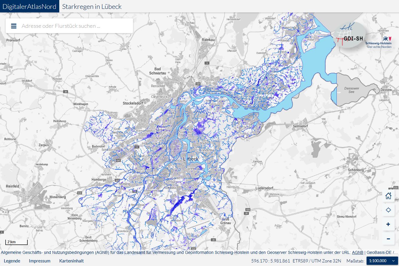
Heavy rain can occur anywhere. The interactive map of Lübeck shows areas in which more water could collect in the event of heavy rain (sinks and flow paths).
By zooming in, individual districts can be viewed more closely.
Please note: The calculations are based on a simple elevation map (digital terrain model), neither the current development nor the sewer network were included. It is therefore a rough overview, from which no concrete statements with specific areas can be derived.
When you click on the map, the WebGIS opens in a new browser window. To return to our website, you can simply close the window.
Exchange of knowledge with other groups of actors
- Awareness-raising and knowledge transfer through workshops for craftsmen, planners and architects
- Queries and discussion of existing experiences
- Networking
In accordance with the slogan “cities learn from cities”, the exchange of experience about good practice and strategies for action with the partner municipalities was another important component.